SAGIS
Welcome to UKWIR’s dedicated SAGIS website, your first port of call for news and information on SAGIS.
What is SAGIS?
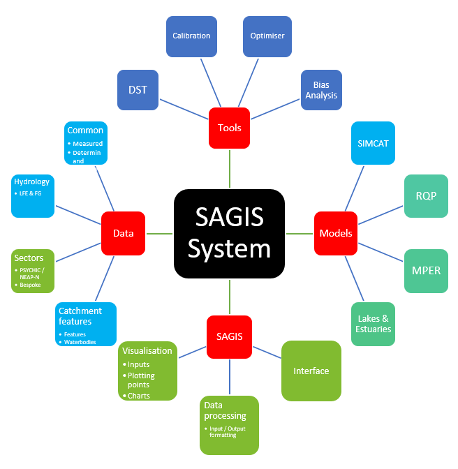
The Source Apportionment Geographical Information System (SAGIS) is a discrete ArcGIS-based digital information management and visualisation platform which serves as an integrated system for modelling water quality in rivers and lakes. SAGIS operates in conjunction with the Environment Agency’s SIMCAT water quality model, together referred to as SAGIS-SIMCAT.
SAGIS is, however, most usefully conceptualised as a ‘system’ of interconnected tools and processes made up of mathematical models such as SIMCAT, MPER and RQP, the ArcGIS interface, data on discharge and water quality, river network and hydrology data, and external tools that rely on SAGIS input and output data, including calibration tools and the Environment Agency’s Catchment Optimiser.
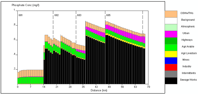
The primary advantage of SAGIS-SIMCAT is that it provides a breakdown of chemical inputs to rivers and lakes from different contributing sectors. This enables Regulators and Water Companies to use a common system to develop effective, evidence-based Programmes of Measures to support asset management and catchment planning functions whilst also maintaining the Polluter Pays Principle.
In the most recent round of business planning for PR19, SAGIS outputs have served as the main evidence base for identifying wastewater treatment works requiring schemes to control discharges of phosphorus. SAGIS-SIMCAT is now firmly embedded within business-as-usual processes and will serve as the regulatory agencies’ (Environment Agency, Natural Resources Wales and the Scottish Environment Protection Agency) primary catchment planning tool until at least 2027. SAGIS-SIMCAT has full coverage of England, Wales and Scotland.
Refer to the ‘Useful links’ page for information on the latest SAGIS related publications and reports and to the ‘Contact us’ page for information on how to obtain SAGIS.


